


Scheduled Monument Consent
3 minutes reading time.
What is Scheduled Monument Consent?
Scheduled Monument Consent (SMC) is the permission from Historic England and DCMS that allows us to excavate on a scheduled monument. Both our archaeological sites of Magna and Vindolanda Roman forts are scheduled. To get permission we put forward our reasons for wanting to explore certain areas and what we hope to learn.
Why are we excavating?
In recent years, we have seen that Magna Fort has had changes to its vegetation cover and environment. Extreme weather events, such as periods of dry heat, followed by heavy rainfall are impacting the landscape and ground conditions. Water, oxygen, and minerals are penetrating deeper into the anaerobic (oxygen free) environments. This puts our vital archaeological and environmental information held in those deposits at risk. It also raises new challenges for land management, preservation, and research.
What do we hope to learn?
The Magna project is designed to examine three areas of the site, from north to south. This spread builds up a profile of the way the land has been used from ancient to modern times. We have combined archaeological investigation with non-intrusive survey, which builds and improves on previous geoarchaeological work. The legacy of the five-year project will be an informed management plan for Magna Roman Fort. This will provide the us with the knowledge needed to preserve this irreplaceable landscape for years to come.
In this project, the we propose to investigate:
- The relationship between the landscape and the layers of Roman occupation, and the ways the Romans adapted to the landscape and worked within its parameters and limits.
- The relationship between water, desiccation, preservation. In particular, we are looking at the impact of historic farming practices and climate change on historic remains such as Magna on Hadrian’s Wall.
- The ways in which the fields of archaeology, geoarchaeology and land management can enable us to understand and conserve this precious resource for the benefit of future generations.
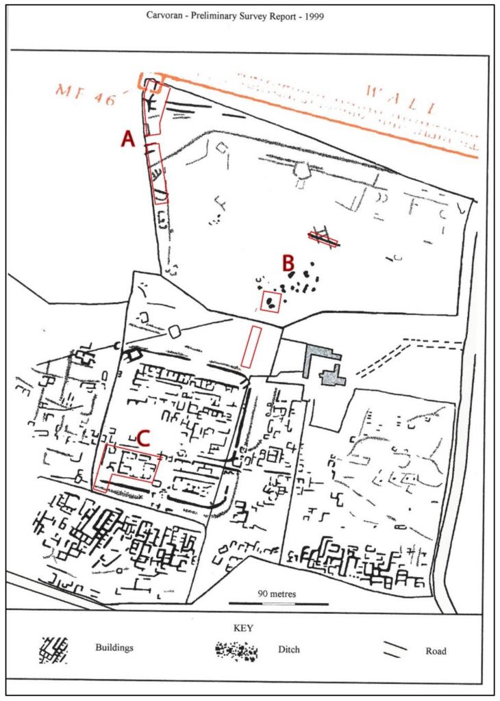
Where are we excavating?
The scope of the Magna research project is limited to three areas: A, B and C. The three areas will give us a more thorough appreciation of water flow and historic land use. This includes an understanding of landscape formation, relationships, and intensity of use, from the pre- Roman period to modern days. An improved understanding of the site’s formation process is necessary for us to be able to accurately quantify the threat levels to Magna, for the present and the future, and inform a meaningful management strategy.
We have worked north to south, starting in area A around the vallum diversion and milecastle 46 before moving to B (the lake side and well complex) and finally we reached C, the site of the historic excavation of the praetorium and southern fort defences.